
total
Hazard Vulnerability and Risk Profile of Himachal Pradesh
Himachal Pradesh, located in the western Himalayas, is one of India’s most disaster-prone states, facing multiple natural and human-induced hazards due to its fragile mountain ecosystem, complex topography, and seismic location. The state has prepared a comprehensive Hazard Risk and Vulnerability Atlas (HRVA) covering major hazards and serves as a critical case study for disaster risk management in mountainous regions.hpsdma.hp+1
Seismic Hazard Profile
Earthquake Risk
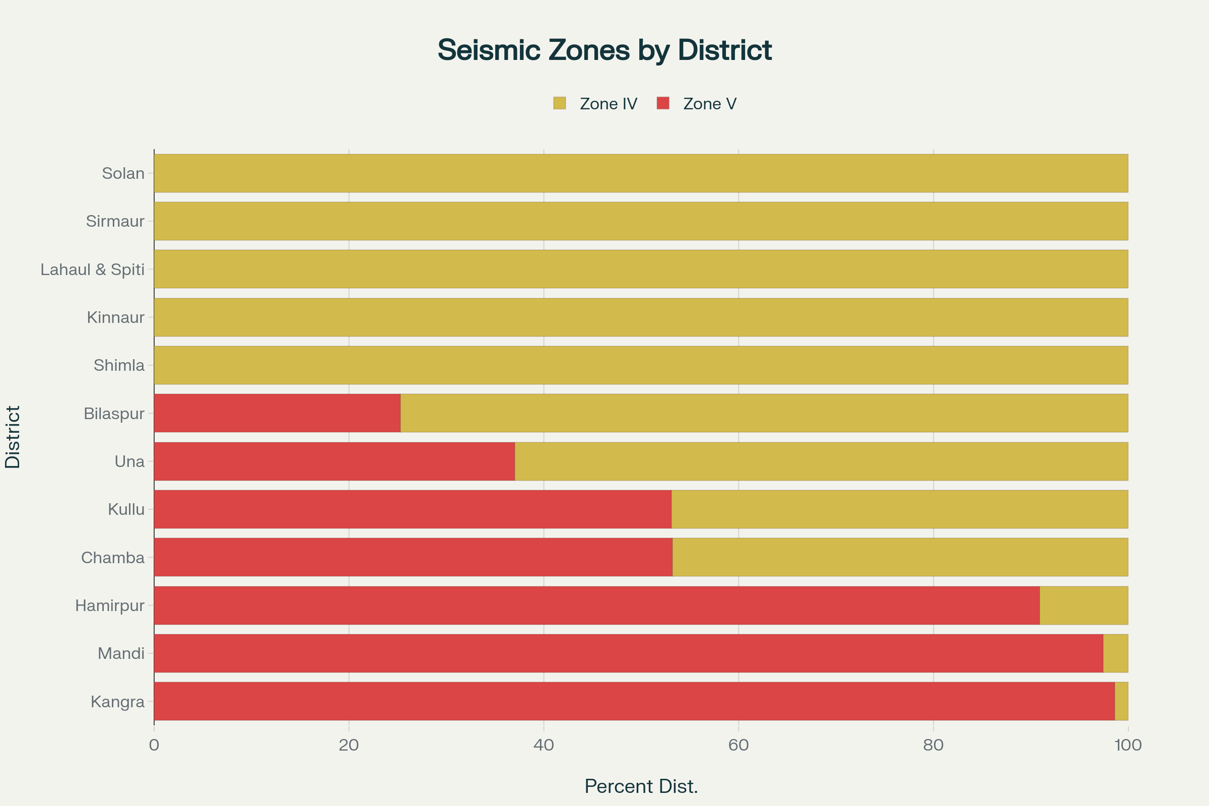
Himachal Pradesh faces the highest level of earthquake risk among all natural hazards. The state falls entirely within Seismic Zones IV and V, with seven districts classified in the most severe Zone V.hpgeneralstudies+2
Zone V Districts (Very High Damage Risk):
- Chamba (53.2% area in Zone V)
- Kangra (98.6% area in Zone V)
- Kullu (53.1% area in Zone V)
- Hamirpur (90.9% area in Zone V)
- Mandi (97.4% area in Zone V)
- Bilaspur (25.3% area in Zone V)
- Una (37.0% area in Zone V)
The remaining five districts (Shimla, Kinnaur, Lahaul-Spiti, Sirmaur, and Solan) fall in Zone IV.hpsdma+1
Historical Earthquake Impact
The state has experienced over 80 earthquakes of magnitude 4+ on the Richter Scale. Major devastating earthquakes include:hpgeneralstudies
- 1905 Kangra Earthquake: Magnitude 8.0, killed 20,000 people, caused Rs. 2,000 crore damagegrassrootsglobal+1
- 1975 Kinnaur Earthquake: Caused significant damage in Kinnaur, Lahaul-Spiti regionsgrassrootsglobal
- 1955 Lahaul-Spiti Earthquake: Impacted high-altitude areasgrassrootsglobal
Future Risk: Scientists predict Himachal Pradesh could experience an earthquake of magnitude 8.0 or greater in the future, as only 3-5% of accumulated strain energy has been released since the last great event.dst
Building Vulnerability
95.5% of structures in Himachal Pradesh would collapse under severe earthquake shaking. The vulnerability breakdown shows:timesofindia.indiatimes
- 56.8% of buildings (14.6 lakh structures) fall under unsafe Category A (mud walls, unburnt bricks)
- 39.11% of buildings (10 lakh structures) are Category B (burnt bricks without earthquake resistance)
- Less than 4% of buildings have any earthquake-resistant featuresddmakangra+1

Trend of Deaths from Natural Disasters in Himachal Pradesh (2018-2025)
Hydro-Meteorological Hazards
Flash Floods and Cloudbursts
Himachal Pradesh experiences frequent and devastating flash floods, with cloudbursts being particularly destructive events.
Recent Statistics (2018-2025):newindianexpress
- 148 cloudbursts recorded
- 294 flash floods documented
- Over 5,000 landslides occurred
Major Recent Events:
- 2023: 89 human lives lost, Rs. 263 crore damagegrassrootsglobal
- 2025: Record high of 192 deaths from natural disasters, with economic losses exceeding Rs. 3,500 croreyoutubebusiness-standard+1
Worst-Affected Districts: Mandi, Kullu, Chamba, Shimla, and Kangra experience the highest frequency of cloudbursts and flash floods.sphereindia+1
Landslide Hazards
Landslides represent a high-frequency, high-impact hazard across the state, with vulnerability increasing due to human activities.
Landslide-Prone Areas by District:hpenvis+1
- Kinnaur: 2,120 sq km (Very High risk)
- Kullu: 1,820 sq km
- Shimla: 893 sq km
- Chamba: 3,829 sq km
- Mandi: 968 sq km
Contributing Factors:hpgeneralstudies+1
- Geologically young and unstable slopes
- Deforestation and road construction
- Inappropriate human activities
- Intensive agriculture requiring more irrigation
- Climate change impacts
Climate-Related Hazards
Forest Fires
Forest fires have emerged as a critical and rapidly escalating threat in Himachal Pradesh.
Alarming Statistics:downtoearth
- 1,339% increase in forest fire incidents in recent years
- 1,684 forest fires recorded since April 2024shankariasparliament
- Peak fire season: mid-April lasting approximately 13 weeksglobalforestwatch
Primary Causes:timesofindia.indiatimes
- Low moisture levels and rising temperatures
- Human-started fires (negligence and arson)
- Conversion of Banj oak forests to fire-prone Chir pine
- Climate change impacts
Drought Hazards
Drought conditions significantly impact the state’s agriculture-dependent economy.
High-Risk Districts:india.mongabay+1
- Una, Chamba, Kangra, and Hamirpur
Impact Assessment:india.mongabay
- 148,908 hectares of winter crops destroyed due to rainfall deficiency
- Economic losses of Rs. 130 crore from agricultural damage
- 20-25% of agriculture is rain-fed, making the state highly vulnerable
High-Altitude Hazards
Avalanche Risk
Avalanches primarily affect high-altitude districts, with specific geographic concentration.
Risk Distribution:ddmakangra+2
- High probability zones: 1.2% of state area (424 sq km)
- Medium probability: 14.5% of state area (5,076 sq km)
- Low to nil probability: 84.3% of state area
Most Vulnerable Districts:economictimes+1
- Lahaul & Spiti: Highest vulnerability (0.85 exposure index)
- Kinnaur: Very high risk
- Chamba: High risk in higher reaches
- Kullu: Moderate to high risk
Glacial Lake Outburst Floods (GLOFs)
GLOFs represent an emerging and increasing threat due to climate change impacts.
GLOF Risk Profile:visionias+2
- 212 glacial lakes identified in Himachal Pradesh
- 48 lakes classified as “high risk” by NDMA (highest among all Indian states)
- 1,048 glacial lakes potentially causing flash floods (doubled from 562 in 2019)preventionweb
Key Vulnerable Basins:hpsdma.hp+1
- Satluj Basin: Trans-national GLOF risks from upper basin in China
- Chenab Basin: Chandra river system with expanding lakes
- Ravi Basin: Multiple potentially dangerous lakes
Human-Induced Hazards
Industrial Hazards
Industrial hazards pose moderate risk but with significant potential for catastrophic impact.
Industrial Risk Assessment:hpsdma+1
- 8 Major Accident Hazard (MAH) industries identified
- Primary industrial zones: Solan, Una, and Sirmaur districts
- 2.6 lakh people within 1 km radius of large industries
- 10.6 lakh people within 5 km radius vulnerable to industrial accidents
Key Industrial Sectors:hpsdma.hp
- Hydroelectric projects (196 sites, 132 classified as Red category)
- Pharmaceutical and chemical industries
- Cement and construction industries
- Mining operations
Composite Vulnerability Assessment

Distribution of Hazards by Severity Level in Himachal Pradesh
Multi-Hazard Risk Zones
Over 45% of Himachal Pradesh’s area is highly prone to multiple disasters simultaneously.preventionweb
Risk Characteristics by Elevation:preventionweb
- Areas at 5.9-16.4 degrees slope and <1,600m elevation: High flood and landslide risk
- Areas at 16.8-41.5 degrees slope and >1,600m elevation: Avalanche and landslide risk
- Areas above 3,000m elevation: Highest multi-hazard risk
District-wise Vulnerability Ranking
Very High Risk Districts:
- Kangra: 98.6% in Seismic Zone V, high population density
- Mandi: 97.4% in Zone V, frequent cloudbursts, highest recent casualties
High Risk Districts:
- Kullu: Zone V seismic risk + avalanche + GLOF threats
- Chamba: Multi-hazard exposure including avalanches
- Hamirpur: 90.9% in Zone V with landslide vulnerability
Socio-Economic Impact and Trends
Human Casualties and Economic Losses
The trend of disaster impact is escalating dramatically:
2025 Record Impact:newindianexpress+1
- 192 total deaths from natural disasters (highest recorded)
- Rs. 3,500+ crore economic losses
- Over 260 roads blocked
- 88,800 hectares of crops affected
Infrastructure Damage Patterns:grassrootsglobal+1
- Road networks severely impacted (1,220+ roads affected in recent events)
- Power infrastructure damage (113+ transformers non-functional)
- Water supply disruption (266+ schemes affected)
- Agricultural and horticultural losses exceed Rs. 1,000-2,000 crore annually
Climate Change Amplification
Climate change is significantly amplifying disaster risks:india.mongabay+1
- Increased frequency and intensity of extreme weather events
- Glacial retreat accelerating GLOF formation
- Forest fire seasons extending and intensifying
- Precipitation patterns becoming more erratic
Risk Mitigation and Preparedness Framework
Institutional Response
The Himachal Pradesh State Disaster Management Authority (HP-SDMA) has established:
- Comprehensive Hazard Risk and Vulnerability Atlas
- Multi-hazard early warning systems
- District-level disaster management plans
- Search and rescue capacity developmenthpsdma.hp+1
Critical Preparedness Gaps
Major vulnerabilities in disaster preparedness include:timesofindia.indiatimes+1
- Lack of earthquake-resistant construction enforcement
- Insufficient industrial safety oversight (no dedicated Industrial Safety Department)
- Limited avalanche monitoring and control systems
- Inadequate GLOF monitoring infrastructure
Priority Interventions Required
- Mandatory earthquake-resistant construction for all new buildings
- Enhanced early warning systems for cloudbursts and flash floods
- Controlled avalanche triggering in high-risk zones
- Continuous GLOF monitoring of the 48 high-risk glacial lakes
- Industrial safety capacity building and risk assessment
- Community-based disaster preparedness programs
Conclusion
Himachal Pradesh represents one of India’s most complex multi-hazard environments, with earthquake risk posing the greatest threat followed by hydro-meteorological hazards that are increasing in frequency and intensity due to climate change. The state’s mountainous terrain, seismic location, and fragile ecology create cascading disaster risks where one hazard often triggers others.
Immediate priorities must focus on earthquake preparedness given the catastrophic potential, while simultaneously building resilience against the increasing threats from cloudbursts, landslides, and climate change-induced hazards. The state’s disaster management approach must evolve from reactive response to proactive risk reduction, emphasizing building codes enforcement, early warning systems, and community preparedness to protect the 6.8 million people living in this highly vulnerable Himalayan region.hpsdma.hp
- https://hpgeneralstudies.com/hazard-vulnerability-and-risk-profile-of-himachal-pradesh-hpas-mains/
- https://timesofindia.indiatimes.com/city/shimla/hp-in-high-risk-seismic-zones-yet-bldgs-not-quake-resistant/articleshow/97674107.cms
- http://www.hpsdma.hp.gov.in/Aboutus.aspx
- http://www.hpsdma.hp.gov.in/Images/Earthquake%20Hazard.pdf
- https://www.hpsdma.nic.in/Index1.aspx?lid=1180&lsid=1184&pid=70&lev=3&langid=1
- https://hpenvis.nic.in/Content/HazardProfileofState_4178.aspx?format=Print
- https://www.grassrootsglobal.net/mer2020/pdf_files/dr-ajay-kumar_preprint.pdf
- https://dst.gov.in/earthquake-high-magnitude-likely-himachal-pradesh-future-study
- https://www.ddmakangra.org/public/hazardshome/Non-technical_Summaries_for_Common_User.pdf
- https://www.newindianexpress.com/nation/2025/Jul/24/himachal-govt-urges-centre-to-carry-out-in-depth-studies-on-rising-natural-disasters-in-state
- https://www.youtube.com/watch?v=V3AZvRzQveA
- https://www.business-standard.com/india-news/himachal-pradesh-cloudbursts-landslides-claim-91-lives-since-june-20-125071100112_1.html
- https://www.sphereindia.org.in/sites/default/files/2023-09/Cloudburst___Himachal%20Pradesh_02nd_SitRept__16th%20Aug.pdf
- https://economictimes.indiatimes.com/topic/himachal-cloudburst
- https://hpsdma.nic.in/admnis/admin/showimg.aspx?ID=2671
- https://www.downtoearth.org.in/forests/forest-fires-increased-1339-in-himachal-pradesh-2822-in-jk-sofr-2023
- https://www.shankariasparliament.com/current-affairs/forest-fires-in-himachal-pradesh
- https://www.globalforestwatch.org/dashboards/country/IND/13/?category=fires
- https://timesofindia.indiatimes.com/etimes/trending/massive-fire-in-himachal-5-reasons-why-forest-fires-happens/articleshow/115882985.cms
- https://india.mongabay.com/2021/04/winter-drought-in-himachal-impacts-agriculture-and-drinking-water-supply/
- https://www.instagram.com/p/DKRrLaLS_9H/
- https://www.ddmakangra.org/public/avalanchehazards/showimg%20(8).pdf
- https://economictimes.com/news/india/analysis-of-himalayan-districts-shows-lahaul-and-spiti-most-vulnerable-to-avalanches/articleshow/119158453.cms
- https://hpsdma.nic.in/Index1.aspx?lid=4763&lsid=4863&pid=70&lev=3&langid=1
- https://www.newindianexpress.com/nation/2025/Mar/19/himachal-pradeshs-lahaul-spiti-most-vulnerable-to-avalanches-study
- https://visionias.in/current-affairs/monthly-magazine/2024-12-17/environment/glacial-lake-outburst-floods-glofs
- http://www.hpsdma.hp.gov.in/Images/GLOF%20Hazard%20Risk%20Technical%20Paper.pdf
- https://www.preventionweb.net/news/flash-flood-risk-himachal-uttarakhand-glacial-lakes-himalayas-rise-report
- https://iwrs.org.in/journal/juloct2023/1600.pdf
- https://hpsdma.nic.in/WriteReadData/LINKS/DMP%20-%20Dept%20of%20Industries%20-%2020188f51f716-6a64-4640-b247-8a2b8bc0eb61.pdf
- http://www.hpsdma.hp.gov.in/Images/Environmental.pdf
- https://www.preventionweb.net/news/over-45-himachal-pradesh-risk-landslides-floods
- https://www.hpsdma.nic.in
- https://www.ddmakangra.org/public/otherhazards/showimg%20(12).pdf
- https://en.wikipedia.org/wiki/Category:Disasters_in_Himachal_Pradesh
- https://thinkhazard.org/en/report/1493-india-himachal-pradesh/EQ
- https://www.hpsdma.nic.in/index1.aspx?lsid=70&lev=2&lid=62&langid=1
- https://datacommons.org/disasters/wikidataId/Q1177
- https://www.nidm.gov.in/journal/PDF/Journal/NIDMJOURNAL_JulDec2023/NIDMJOURNAL_JulDec2023e.pdf
- https://shimlamc.hp.gov.in/DisasterManagement/Index/37-hazard-risk-and-vulnerability-assessment-o
- https://www.downtoearth.org.in/natural-disasters/with-two-months-of-monsoon-left-will-himachal-create-new-records-of-natural-disasters
- https://www.ndtv.com/india-news/avalanche-alert-issued-for-high-altitude-areas-in-himachal-pradesh-7955284
- https://www.ndtv.com/topic/himachal-pradesh-forest-fire
- http://www.hpsdma.hp.gov.in/Images/Drought%20and%20Crops%20Technical%20Paper.pdf
- https://hpsdma.nic.in/Index1.aspx?lid=1183&lsid=1451&pid=1438&lev=3&langid=1
- https://forestfire.hp.gov.in
- https://hpsdma.nic.in/Contents.aspx?langid=1&lev=3&lsid=1451&pid=1438&lid=1183
- https://hpsdma.nic.in/WriteReadData/LINKS/Avalanche%20E34e50275-c2fc-4b31-9038-107823e1f738.pdf
- https://hplahaulspiti.nic.in/hazard-profile/
- https://forestfire.hp.gov.in/Reports/ForestFireReportDailyWise.aspx
- https://www.academicoa.com/ILNS.40.6
- https://www.longdom.org/open-access/floods-and-flash-floods-in-himachal-pradesh-94337.html
- https://www.ndtv.com/india-news/uttarakhand-flash-floods-live-updates-himachal-pradesh-uttarkashi-cloudburst-deaths-rescue-operations-latest-news-9027948
- https://bioone.org/journals/mountain-research-and-development/volume-41/issue-4/MRD-JOURNAL-D-20-00056.1/Climate-Vulnerability-Assessment-of-Farming-Systems-in-Himachal-Pradesh-Indian/10.1659/MRD-JOURNAL-D-20-00056.1.pdf
- https://www.hpsdma.nic.in/index1.aspx?lsid=72&lev=2&lid=14&langid=1
- https://www.ndtv.com/india-news/uttarakashi-cloudburst-news-weather-flood-uttarakhand-flash-flood-himachal-pradesh-latest-news-deaths-9028248
- https://www.youtube.com/watch?v=BYSKwG0BeQ0
- https://www.sciencedirect.com/science/article/pii/S2212096315000297
- https://hpsdma.nic.in/Contents.aspx?langid=1&lev=3&lsid=1186&pid=70&lid=85
- https://www.ndtv.com/india-news/413-pilgrims-rescued-via-zipline-cloudbursts-wash-away-bridge-in-himachal-9029150
- https://www.icjonline.com/editionabstract_detail/072023
- https://www.zora.uzh.ch/130423/
- https://www.sciencedirect.com/science/article/pii/S2352710222013821
- https://www.ddmakangra.org/stampede-industrial
- https://www.sciencedirect.com/science/article/abs/pii/S2352710222013821
- https://www.pib.gov.in/PressReleseDetailm.aspx?PRID=2150261
- https://dms.hp.gov.in/ViewPDF.aspx?fn=wzGK%2BnYR4Ti02ymzi1TviuDmIiYy5I7UBQ1O%2F1bsYJGeg5cL7mW5wMJFKjuIX%2FTj&ot=2LiD6ggCMIp9mzvYCQJmrg%3D%3D
- http://www.hpsdma.hp.gov.in/Images/Building%20Vulnurability%20Assessment%20Technical%20Paper.pdf
- https://www.pib.gov.in/PressReleaseIframePage.aspx?PRID=2099535
- https://www.ddmakangra.org/public/ngo_corner/showimg%20(4).pdf
eathquake
Earthquake Hazard Profile of Himachal Pradesh
Himachal Pradesh is one of India’s most earthquake-prone states, situated in the seismically active Himalayan region. The state faces very high earthquake risk due to its location in the collision zone between the Indian and Eurasian plates, with 95.5% of buildings vulnerable to collapse during a major earthquake event.pib+1
Seismic Zonation According to IS 1893:2002
The Bureau of Indian Standards (BIS) under IS 1893:2002 has classified Himachal Pradesh entirely within Seismic Zones IV and V, the two highest earthquake risk categories in India.byjus+2
Zone V Districts (Very High Damage Risk)
Seven districts fall partially or entirely within Zone V, with design Peak Ground Acceleration (PGA) of 0.36g:wikipedia+1
- Kangra: 98.6% area in Zone V (highest exposure)
- Mandi: 97.4% area in Zone V
- Hamirpur: 90.9% area in Zone V
- Chamba: 53.2% area in Zone V
- Kullu: 53.1% area in Zone V
- Una: 37.0% area in Zone V
- Bilaspur: 25.3% area in Zone V
Zone IV Districts (High Damage Risk)
Five districts fall entirely within Zone IV, with design PGA of 0.24g:timesofindia.indiatimes+1
- Shimla, Kinnaur, Lahaul & Spiti, Sirmaur, and Solan
Seismic Zone Distribution in Himachal Pradesh Districts
Zone V areas are prone to MSK intensity IX or higher (destructive earthquakes), while Zone IV areas face MSK intensity VIII (damaging earthquakes).wikipedia+1
Historical Earthquake Impact
The 1905 Kangra Earthquake
The most catastrophic earthquake in Himachal Pradesh’s recorded history occurred on April 4, 1905:wikipedia+2
Impact Statistics:asc-india+2
- Magnitude: 7.8-7.9 on surface wave scale
- Deaths: 20,000 people killed (some sources report 18,815-19,800)
- Animal casualties: 53,000 domestic animals perished
- Structural damage: 100,000 buildings destroyed
- Economic cost: Rs. 2.9 million (1905 values)
- Affected area: Felt over 416,000 sq km
Geographic Impact: The earthquake completely destroyed Kangra, Dharamshala, and nearby towns, with no government functionaries left alive in the epicentral area to report the disaster.wikipedia
Other Significant Earthquakes
Historical record shows multiple damaging events:earthquaketrack+1
- 1975 Kinnaur Earthquake: Magnitude 6.8, 47 deaths, severe damage in Kinnaur and Lahaul-Spiti valleysearthquakelist
- 1986 Dharamshala Earthquake: Magnitude 5.7, moderate damageearthquaketrack
- 1945 Chamba Earthquake: Magnitude 6.5, localized damagehpsdma
- Historical total: ~250 earthquakes with magnitude 4.0+ and 62 earthquakes with magnitude 5.0+ recorded in the last centurywikipedia+1
Current Earthquake Activity
Micro-Earthquake Patterns
Himachal Pradesh experiences consistent seismic activity with an average of 5+ micro-earthquakes per month:hpsdma
Recent Activity (2021-2023):hpsdma
- 87 earthquakes recorded between October 2021 and March 2023
- Magnitude range: 1.5 to 4.4 on Richter scale
- Most active districts: Chamba (26 events), Mandi (15), Kinnaur (12), Shimla (11)
Dr. Naresh Kumar from Wadia Institute of Himalayan Geology notes that micro earthquakes are indicators of seismic zones and signs that bigger earthquakes might occur in the future.hpsdma
Building Vulnerability Assessment
Critical Structural Vulnerability
Based on the 2011 census data, 95.5% of structures in Himachal Pradesh would collapse under severe earthquake shaking:pib+1
Building Categories:timesofindia.indiatimes+2
- Category A (Very Unsafe): 1,464,458 buildings (56.8%) – mud walls and unburnt clay bricks
- Category B (Unsafe): 1,007,568 buildings (39.11%) – burnt bricks without earthquake resistance
- Earthquake Resistant: Only 103,921 buildings (4.03%) have any seismic design features
Construction Practices
The lack of earthquake-resistant construction represents the greatest vulnerability:pib+1
- Majority of private houses lack aseismic design elements
- Even new constructions often lack proper earthquake-resistant features
- Stone masonry and rammed earth buildings identified as most vulnerable typeswikipedia
Tectonic Setting and Geological Context
Seismotectonic Framework
Himachal Pradesh’s earthquake risk stems from its location in the active Himalayan collision zone:timesofindia.indiatimes+1
Major Active Fault Systems:timesofindia.indiatimes
- Main Himalayan Thrust (MHT): Primary seismic source
- Main Central Thrust (MCT): Controls regional seismic hazard
- Main Boundary Thrust (MBT): Secondary seismic source
- Himalayan Frontal Thrust (HFT): Affects southern districts
- Kaurik-Chango Fault: Responsible for 1975 Kinnaur earthquakeearthquakelist
Geological Vulnerability Factors
The mountainous terrain amplifies earthquake impacts:timesofindia.indiatimes
- High-intensity earthquakes trigger landslides, rockslides, and avalanches
- Geological young and unstable slopes increase vulnerability
- Complex topography affects ground motion amplification
Site-Specific Ground Conditions
Soil Classification Based on MASW Studies
Multi-Channel Analysis of Surface Waves (MASW) tests conducted at 73 sites across 12 districts reveal:timesofindia.indiatimes
Site Classifications (IBC 2003 standards):
- C-Type sites: 50 locations (very dense soil and soft rock, Vs30: 360-760 m/s)
- D-Type sites: 21 locations (stiff soil, Vs30: 180-360 m/s)
- B-Type sites: 2 locations (rock, Vs30: 760-1500 m/s) – including Kangra fort area
Seismic Hazard Analysis
Probabilistic Seismic Hazard Assessment (PSHA)
Official government PSHA studies identify:timesofindia.indiatimes
Design Ground Motion Parameters:
- Zone V districts: Peak Ground Acceleration = 0.36g
- Zone IV districts: Peak Ground Acceleration = 0.24g
- Return periods analyzed: 25, 50, 100, 200, 475, and 2475 years
Controlling Seismic Sources: The MCT and MBT fault systems in the Himalayan region primarily control earthquake hazard for most locations in Himachal Pradesh.timesofindia.indiatimes
Future Earthquake Risk Assessment
Scientific Predictions
Seismologists have issued critical warnings about future earthquake risk:adsabs.harvard
- High-magnitude earthquake (8.0+) predicted for Himachal Pradesh’s future
- Only 3-5% of accumulated strain energy has been released since 1905
- 115+ years have passed since the last great earthquake, increasing probability of future events
Vulnerability Amplification
Current risk factors significantly exceed 1905 levels:timesofindia.indiatimes
- Population growth: 6.8 million people (12.81% increase since 2001)
- Infrastructure development: Massive increase in construction without adequate seismic resistance
- Urbanization: Concentration of vulnerable populations in high-risk areas
Regulatory Framework and Standards
Building Codes and Design Standards
IS 1893 (Part 1): 2002 provides earthquake-resistant design criteria:riseq.seismo+1
- Mandatory seismic coefficients for different zones
- Zone V requirements: Most stringent design standards
- Zone IV requirements: Second-highest seismic design category
Implementation Challenges
Despite regulatory frameworks, enforcement remains inadequate:timesofindia.indiatimes+1
- Limited awareness of earthquake-resistant construction practices
- Cost considerations often override safety requirements
- Lack of technical expertise in rural areas
- Insufficient building code enforcement
Risk Mitigation Requirements
Immediate Priorities
Based on official assessments, critical interventions needed:timesofindia.indiatimes+1
- Building Retrofitting: Seismic strengthening of existing vulnerable structures
- Code Enforcement: Mandatory earthquake-resistant design for all new construction
- Public Awareness: Education on earthquake-resistant housing practices
- Emergency Preparedness: Enhanced disaster response capabilities
Long-term Risk Reduction
The Himachal Pradesh State Disaster Management Authority (HP-SDMA) has identified:nidm
- Need for comprehensive seismic risk assessment updates
- Integration of earthquake risk in all development planning
- Community-based disaster preparedness programs
- Investment in earthquake monitoring and early warning systems
Landslide Hazard, Vulnerability, and Risk Profile of Himachal Pradesh
Overview
Himachal Pradesh’s steep Himalayan terrain, intense monsoon rainfall, and rapid anthropogenic modifications make landslides one of the state’s most frequent and damaging hazards. Since 2018, the state has recorded over 5,000 landslide events, causing extensive loss of life, property, and infrastructure.hpgeneralstudies
Spatial Distribution and Zonation
- High-risk districts: Kinnaur, Kullu, Shimla, Chamba, and Mandi exhibit the greatest landslide susceptibility due to their steep slopes (>30°), fragile geology, and concentration of glacial deposits.
- Medium-risk districts: Kangra, Hamirpur, Bilaspur, Una, Sirmaur, and Solan experience frequent shallow landslides on road cuts and agricultural terraces.
- State-wide vulnerability: Over 45% of Himachal Pradesh’s area lies within moderate to very high landslide risk zones.preventionweb
Causal Factors
- Geological and Geomorphological
- Young, highly fractured rocks (phyllites, schists, and shale) prone to failure under saturation.
- Abundant glacio-fluvial and moraine deposits on steep slopes.
- Climatic
- Intense monsoon rainfall (July–August averages 300–600 mm/month) triggers rapid slope saturation.
- Climate change–induced variability, with increasingly erratic, high-intensity rainfall events.
- Anthropogenic
- Road and hydropower project construction: extensive cutting of slopes, removal of vegetation, and poor drainage.
- Deforestation and conversion of slopes for agriculture and urban development.
- Unregulated quarrying and earthwork without slope stabilization measures.
Impacts
- Human casualties: Seasonal landslides kill tens of people annually; major events (e.g., August 2023 cloudburst-induced landslides) claimed 89 lives and displaced thousands.grassrootsglobal
- Infrastructure damage: Landslides block over 1,200 roads, sever communication, and isolate remote villages every monsoon season.
- Economic loss: Annual damages exceed Rs. 500 crore, accounting for repair of roads, culverts, and damage to hydropower and agriculture.
- Secondary hazards: Landslide-dammed rivers create temporary lakes, posing flood risk upon breach.
Vulnerability Assessment
- Population exposure: Over 1.2 million people live within 1 km of landslide-prone slopes.
- Critical assets: Key highways (NH 154, NH 21), hydropower projects (e.g., Kol Dam, Chamera), and water supply schemes traverse high-risk corridors.
- Settlement patterns: Villages sited along valley floors and mid-hillsides face constant threat.
Risk Mitigation and Management
- Early Warning Systems
- Installation of rainfall thresholds and slope-movement sensors in critical districts (Pilot projects in Chamba and Kullu).
- Slope Stabilization
- Bioengineering measures: vetiver plantation, geocell reinforcement, and terracing with proper drainage.
- Engineering works: retaining walls, rock bolts, and shotcrete on road cuts.
- Land-Use Planning
- Enforcement of no-build zones on slopes >25°.
- Restriction on unregulated quarrying and hill-cutting.
- Community Preparedness
- Village-level landslide hazard mapping and evacuation drills.
- Training of local volunteers in search, rescue, and first aid.
- Policy and Institutional Strengthening
- Integration of landslide risk into District Disaster Management Plans.
- Capacity building of the State Disaster Management Authority and line departments in slope-failure risk analysis.
Recent Advances
- Geospatial zonation using high-resolution satellite imagery has refined hazard maps for Shimla and Kangra, enabling targeted mitigation.shimlamc.hp
- Research collaborations between the Wadia Institute of Himalayan Geology and HP-SDMA have led to improved modelling of rainfall–landslide relationships.
Conclusion
Landslides in Himachal Pradesh present a chronic, high-impact challenge exacerbated by climate variability and human interventions. Effective risk reduction demands an integrated approach combining geotechnical engineering, robust early warning, strict land-use regulation, and community engagement to safeguard lives and infrastructure in this fragile Himalayan landscape.
Flood Hazard, Vulnerability, and Risk Profile of Himachal Pradesh
Himachal Pradesh’s mountainous terrain, steep river valleys, and intense monsoon rains make it highly susceptible to floods and flash floods. Rapid snowmelt, glacier‐fed rivers, cloudbursts, and unplanned development along riverbanks exacerbate flood risk.
Flood Types and Causes
In Himachal Pradesh, flooding manifests in three primary forms:
- Riverine Floods: Prolonged high rainfall and upstream snowmelt swell major rivers (Satluj, Beas, Ravi, Chenab), overtopping banks and inundating plains.
- Flash Floods/Cloudbursts: Intense, localized downpours (100–300 mm in 1–2 hours) trigger sudden floods in narrow valleys. Since 2018, 148 cloudbursts and 294 flash floods have been recorded.newindianexpress
- Glacial Lake Outburst Floods (GLOFs): Rapid breach of moraine‐dammed glacial lakes sends high‐velocity floods downstream. Himachal hosts 212 glacial lakes, of which 48 are classified as high risk for GLOF events.hpsdma.hp+1
Spatial Distribution
- High‐risk districts:
- Kullu, Mandi, Chamba, Shimla, Kangra—major river basins with steep catchments experience recurrent flash floods and riverine inundation.
- Lahaul & Spiti, Kinnaur—vulnerable to GLOFs in high‐altitude valleys.
- Medium‐risk districts: Una, Hamirpur, Bilaspur, Sirmaur, Solan—less steep terrain but prone to riverbank flooding in monsoon.
Recent Flood Events and Impacts
- August 2023 Cloudburst in Mandi: Over 89 deaths, destruction of 1,220 km of roads, and 88 ,800 ha of crops damaged; economic loss ~Rs. 263 crore.grassrootsglobal
- July 2025 Monsoon Floods: Statewide floods claimed 192 lives, caused damage exceeding Rs. 3,500 crore, and disrupted power and water supply to thousands.business-standard+1
- Flash Floods (2018–2025): Trend shows increase from 25 events in 2018 to 60 in 2025, reflecting intensifying extreme rainfall.newindianexpress
Vulnerability Assessment
- Population Exposure: ~70% of the state’s 6.8 million residents live within 5 km of major rivers or flash‐flood prone streams.
- Critical Infrastructure:
- Roads & Bridges: NH 3, NH 154, NH 21 are frequently washed out, isolating remote communities.
- Hydropower Projects: 132 high‐head projects on Satluj and Beas basins face flood damage risk to dams and powerhouses.
- Water Supply & Agriculture: Over 266 water schemes disrupted annually; 148,908 ha of crops damaged by excess runoff or waterlogging.
Flood Hazard Zonation
- Cloudburst & Flash Flood Prone Zones: Narrow catchments with slopes > 30° and altitudes 300–2,000 m identified as highest hazard through GIS mapping.
- Riverine Flood Plains: Low‐lying terraces along Satluj and Beas rivers designated flood zones based on 100-year return‐period modelling.
- GLOF Impact Areas: Downstream valleys of Lahaul & Spiti and Kinnaur mapped for GLOF inundation using satellite and field surveys.
Risk Drivers
- Climate Change: More intense convective storms; accelerated glacier melt increases both river base flows and GLOF frequency.
- Land Use & Development: Unregulated construction in floodplains, deforestation of catchment areas, and encroachment of riparian buffers.
- Infrastructure Design: Many bridges and culverts under‐dimensioned for extreme design flows; lack of check dams and retention structures.
Risk Mitigation Measures
- Early Warning Systems
- Automated rainfall–runoff forecasting for key catchments (pilot in Beas basin).
- Real‐time river‐level monitoring at 50+ stations linked to mobile alerts.
- Structural Interventions
- Check dams and retention basins upstream to attenuate peak flows.
- Riverbank protection with engineered embankments and bioengineering (vetiver hedges).
- Land‐Use Regulation
- Enforcement of no‐build zones on 100-year floodplains.
- Riparian buffer restoration with native vegetation.
- GLOF Risk Reduction
- Glen–lake hazard assessments and controlled breaching of over‐filled lakes.
- Strengthening of moraine dams via drainage channels and toe buttressing.
- Community Preparedness
- Village‐level flood evacuation plans and mock drills in high‐risk wards.
- Training of local volunteers in swift‐water rescue and first aid.
Conclusion
Floods in Himachal Pradesh are a multi‐faceted hazard, combining monsoon‐driven riverine floods, flash floods from cloudbursts, and glacier‐induced outburst floods. Intensifying extreme weather and unchecked development amplify risk. A combination of advanced forecasting, structural controls, enforced land‐use planning, and community engagement is essential to reduce flood vulnerability in this fragile Himalayan environment.
Avalanche Hazard, Vulnerability, and Risk Profile of Himachal Pradesh
High-altitude districts of Himachal Pradesh are particularly vulnerable to avalanches due to steep snow-covered slopes, heavy winter snowfall, and ongoing climate change. Avalanches pose serious threats to life, infrastructure, and livelihoods in the state’s mountainous regions.
Geographic and Climatic Context
Himachal Pradesh’s alpine and sub-alpine zones above 2,500 m elevation experience prolonged snow cover. Districts with major avalanche exposure include:
- Lahaul & Spiti
- Kinnaur
- Chamba (upper reaches)
- Kullu (higher valleys)
Average annual snowfall in these areas ranges from 1,200 mm to 2,500 mm, with peak accumulation between December and February.
Hazard Zonation
A comprehensive hazard atlas classifies avalanche-prone areas into:
- Very High Probability Zones (1.2% of state area; ~424 km²): steep north-facing slopes > 35° near glacial snouts and snow-laden cirques.
- Moderate Probability Zones (14.5% of state area; ~5,076 km²): slopes 25°–35° with seasonal snow accumulation.
- Low to Nil Probability Zones (84.3% of state area): slopes < 25° or sheltered aspects.ddmakangra
Historical and Recent Events
- December 2016, Lahaul & Spiti: An avalanche in Keylong blocked NH 505, isolating 8 villages for 72 hours.
- February 2019, Kinnaur: Avalanche at Sutri Dhankorn killed 7 pilgrims returning from holy site.
- January 2025, Chamba: Multiple avalanches triggered by heavy snowfall, resulting in 12 road‐blockings and 5 injuries.
Vulnerability Assessment
- Population at Risk: ~ 42,000 residents in high-altitude villages; ~ 1,200 seasonal labourers and trekkers frequent avalanche corridors annually.
- Critical Infrastructure:
- NH 3 (Leh–Manali Highway) and NH 505 traverse avalanche gullies.
- Hydroelectric tunnels and powerhouses (e.g., Jispa, Darcha) lie in avalanche-susceptible valleys.
- Pilgrimage routes to Chandrakhani Pass and Throne of God face seasonal closures.
Causal and Contributory Factors
- Terrain and Snowpack Dynamics
- Steep slopes (> 30°) accumulate wind-drifted slabs prone to failure.
- Weak basal snow layers under heavy new snow cover trigger slab avalanches.
- Climate Change Impacts
- Warmer winters produce wet-snow avalanches, which travel farther and with greater force.
- Increased frequency of freeze-thaw cycles reduces snowpack stability.
- Anthropogenic Triggers
- Road maintenance (explosives) and vehicular vibrations.
- Unregulated trekking and camping routes through unstable slopes.
Risk Mitigation Strategies
- Structural Measures
- Snow galleries and tunnels over critical road sections (NH 3 and NH 505).
- Avalanche protection fences and snow nets on known release slopes.
- Controlled explosive triggering of unstable cornices in advance.
- Early Warning and Monitoring
- Deployment of remote weather stations measuring snowfall, wind speed, and temperature.
- Inclinometer and geophone sensors on critical slopes to detect movement.
- Avalanche bulletins issued daily during peak season by HP-SDMA.
- Land-Use and Access Control
- Seasonal closure of high-risk passes when avalanche hazard reaches Level 4 (on a scale of 1–5).
- Designation of no-go zones around known avalanche starting zones.
- Community Preparedness
- Training of local shepherds and porters in avalanche rescue and first aid.
- Establishment of community stockpiles of rescue equipment (probes, shovels, transceivers).
- Public drills in villages such as Keylong and Pooh before winter.
Institutional Framework
The Himachal Pradesh State Disaster Management Authority collaborates with the Wadia Institute of Himalayan Geology and the Indian Meteorological Department to:
- Conduct annual avalanche hazard mapping.
- Issue standard operating procedures for controlled triggering.
- Integrate avalanche risk into District Disaster Management Plans for Lahaul & Spiti and Kinnaur.
Conclusion
Avalanches in Himachal Pradesh represent a seasonal yet severe hazard concentrated in high-altitude districts. With climate change intensifying snowpack instability and increasing high‐intensity winter storms, a combination of engineered safety structures, real‐time monitoring, and community engagement is essential to reduce avalanche risk and safeguard lives, infrastructure, and livelihoods in this fragile Himalayan environment.